



Europe has spent decades building connectivity on land. High-speed railways, motorways, bridges, tunnels, ports and logistics hubs have transformed the continent into one of the world’s most integrated economic spaces. Yet one of Europe’s oldest connectivity systems—the network of rivers and canals that historically carried people, goods and ideas across borders—has remained strangely peripheral to the strategic debate.
It is time to bring Europe’s blue waterways back to the centre of its connectivity agenda.
This is not simply about moving more cargo from roads to barges. It is about recognising Europe’s rivers as strategic infrastructure: economic corridors, ecological systems, energy assets, water reserves and spaces of territorial cooperation. The Rhine, Danube, Main, Elbe, Seine, Rhône, Po and their tributaries form a continental network whose importance extends far beyond navigation.
The 2026 summer has provided an uncomfortable reminder of this reality. Prolonged drought and extreme heat pushed several of Europe’s major rivers—including the Rhine and Danube—to exceptionally low levels. The European Commission’s Joint Research Centre reported in August that the Rhine and Danube had reached record-low levels in places, after months of deficient rainfall and repeated heatwaves. The consequences were immediate: restrictions on navigation, reduced vessel loads, disruption to logistics and pressure on energy and industrial systems. In parts of the Rhine-Danube system, water became not merely a transport variable but a strategic constraint.
Stay ahead of the geopolitical week.
MD Briefing delivers expert analysis across five global fronts — the Indo-Pacific, energy, geoeconomics, European security, and the Middle East — every Monday morning. Free.
The lesson should not be that Europe cannot rely on its waterways. Quite the opposite. The lesson is that Europe must govern them as a system.
This is where the GAFG Connectivity Doctrine offers a useful conceptual departure. Connectivity is not a collection of individual infrastructure projects; a corridor is an ecosystem, its effectiveness shaped by the interaction of infrastructure, regulation, logistics, institutions, energy, digital systems and the communities it passes through. The doctrine sets this out through five operating principles—systems over projects, governance as the multiplier, interoperability as the binding constraint, complementarity over competition, and an ecosystem logic of connectivity—each insisting that coherence, not capacity, is the true measure of a corridor’s strength.
The geographical map, however, tells only half the story. A river may provide physical connectivity without producing functional connectivity. This distinction is central to the GAFG Connectivity Doctrine: connectivity is not merely the existence of links; it is the coherence of the system in which those links operate.
The Volga offers a striking illustration. Europe’s longest river, it forms a major north–south axis linking the Russian heartland with the Caspian Sea and, through the Volga–Caspian system, the wider International North–South Transport Corridor towards Iran, the Persian Gulf and the Indian Ocean—a role it has played historically, and one that contemporary INSTC plans explicitly build on.
Yet geography here collides with geopolitics. The physical corridor remains, but the war in Ukraine, sanctions and the deterioration of relations between Russia and much of Europe have fragmented the wider connectivity environment in which it might otherwise operate: infrastructure survives while the political and institutional coherence that makes a corridor function as a system breaks down. The Volga belongs in Europe’s blue-waterway debate not because it can simply be folded into a common network under present circumstances, but because it demonstrates the limits of infrastructure once geopolitical coherence disappears—a reminder that connectivity is as much a question of governance as of engineering.
The distinction matters because connectivity should not be measured simply by kilometres of navigable water, railway track or motorway. The relevant question is whether the different components of a corridor can operate together. A corridor is only as connected as its weakest political or institutional link. This is what the doctrine calls interoperability as the binding constraint: in corridor after corridor, the real bottleneck turns out to be misaligned institutions, documentation practices and liability regimes rather than missing infrastructure.
The same principle works in reverse. Where political cooperation, common standards, interoperable infrastructure and institutional trust reinforce one another, a river becomes more than a waterway: it becomes a corridor ecosystem. Where those elements fragment, even a great river can become a series of disconnected national or geopolitical segments. This is the doctrine’s principle of complementarity over competition in practice: corridors function best when governed as a portfolio of mutually reinforcing routes rather than treated as rivals competing for the same traffic.
Europe’s waterways exemplify this principle perfectly.
The Rhine-Danube corridor is already recognised by the European Union as the principal west-east transport axis across continental Europe and contains the longest inland-waterway component of the TEN-T corridors. It connects the North Sea and western European industrial centres through Germany and Austria to Vienna, Bratislava, Budapest, Belgrade, Bucharest and ultimately the Black Sea. It also connects with maritime ports, railways, roads and logistics terminals.
But a river does not respect administrative borders. Its water does not stop at a national frontier, and neither should its governance.
A functioning European blue-waterway system therefore requires far more than dredging individual stretches of river. It requires common standards, coordinated investment, interoperable navigation systems, resilient ports, multimodal terminals, real-time hydrological information and contingency arrangements linking waterways with rail and road. It also requires a new understanding of resilience.
The old model sought to make waterways predictable through engineering. The new challenge is to make the connectivity system adaptable when nature becomes unpredictable.
Low water is only one side of the problem. Flooding can be equally disruptive. Climate change means that Europe’s waterways must increasingly be designed and governed for extremes rather than averages. The European Commission itself has recognised that droughts and floods can temporarily block waterways, reduce vessel loads and force cargo onto other transport modes, while climate change is expected to make such disruptions more frequent.
This makes resilience a connectivity issue.
A resilient blue-waterway strategy would therefore have at least four dimensions.
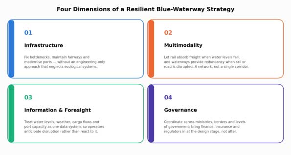
Figure 2. Four dimensions of a resilient blue-waterway strategy, per the GAFG Connectivity Doctrine’s principle that coherence—not capacity—is the measure of a corridor’s strength.
First, infrastructure. Europe must address persistent bottlenecks, improve fairway maintenance and modernise ports and terminals while avoiding an exclusively engineering-driven approach that neglects ecological systems.
Second, multimodality. No river should be expected to carry the entire burden alone. When water levels fall, rail should be able to absorb additional freight; when rail or road corridors are disrupted, waterways should provide redundancy. Connectivity means having alternatives. This is, in essence, the difference between a corridor and a network: a corridor concentrates risk at one point and breaks when that point fails, while a network spreads risk across many links and reroutes around failure. Europe’s blue-waterway system should be designed and governed as the latter.
Third, information and foresight. Water levels, weather patterns, cargo flows and port capacity should increasingly be treated as one interconnected data system. Strategic foresight must become part of corridor management, allowing operators and governments to anticipate disruption rather than merely respond to it.
Fourth, governance. This may be the most important dimension. Europe’s waterways cross multiple jurisdictions and policy areas—transport, environment, agriculture, energy, civil protection and regional development. Their management therefore demands institutional coordination across ministries, borders and levels of government. It also means bringing finance, insurance, logistics operators and regulators into corridor governance at the design stage, not after infrastructure is built, and treating legal certainty on liability and dispute resolution as part of what makes a waterway investment bankable.
The blue-waterway agenda should also extend beyond the traditional Rhine-Danube axis. Europe’s rivers connect its Atlantic, North Sea, Baltic, Mediterranean and Black Sea spaces: the Seine reaches the Atlantic; the Rhine, Meuse and Scheldt converge on the Rotterdam-Antwerp delta on the North Sea; the Oder and Vistula drain north towards the Baltic; the Rhône and Po serve the Mediterranean; and the Dnieper joins the Danube in opening onto the Black Sea—though the Dnieper’s own connectivity, like the Volga’s, has been disrupted by war. The Iberian Peninsula’s Douro, Tagus and Guadalquivir remain comparatively isolated from this network, a reminder that the map of physical waterways is not yet the map of a connected system (Figure 1). The opportunity is to think of these waterways as a continental blue network, linked to maritime ports and land corridors. Europe would not be alone in making this shift. From Africa’s emerging Indian Ocean, Atlantic and Trans-Saharan gateways to the Eurasian corridors linking the Middle Corridor with the International North–South Transport Corridor, the same logic is taking hold elsewhere: the strategic question is no longer which single corridor prevails, but how multiple corridors can be governed to work together as a network of networks.

Figure 1. Europe’s principal river-canal corridors and their sea-basin connections (schematic, not to scale). Dashed lines mark corridors whose physical infrastructure persists but whose connectivity has been geopolitically fragmented.
Such an approach would complement, rather than compete with, Europe’s existing TEN-T architecture. Indeed, the European Commission’s current framework already recognises the importance of inland waterways and multimodal connectivity, while its 2026 Connecting Europe Facility calls explicitly support inland-waterway projects designed to make the network more sustainable, smart and resilient.
The strategic question is therefore no longer whether Europe should use its rivers more intensively. It is whether Europe is prepared to govern them as critical infrastructure. In the language now used for Europe’s maritime chokepoints, the question is whether its river gateways, like its sea straits, are ready to evolve from fixed crossing points into networked governance hubs.
The Danube’s difficult summer of 2026 should be read as an early warning. A waterway cannot be resilient merely because a channel has been dredged or a port modernised. Resilience emerges from the whole corridor—from watershed to river, from port to railway, from data to decision-making, and from one national authority to the next.
Europe’s future connectivity will not be exclusively green, digital or terrestrial. It will also be blue.
And if the Connectivity Doctrine is correct that corridors are governance ecosystems, Europe’s rivers may become one of the most compelling places to demonstrate what that doctrine means in practice: turning fragmented infrastructure into integrated systems, and turning geographical constraints into strategic connectivity. The Global Maritime Governance Forum, convened under the same doctrine around the Strait of Gibraltar, offers one working template for the standing, cross-border dialogue Europe’s rivers now need of their own.
